loader-image
18°C

ISLANTILLA - RÍO PIEDRAS

MTB/GRAVEL ROUTE

Ruta en bicicleta Islantilla - Río Piedras
Icono azul de una señal de dirección que representa la distancia de la ruta.

Distance

60.92 km

Icono azul con un triángulo y una pendiente que representa la altitud o desnivel de la ruta en bicicleta.

Altitude

664 m

Icono azul de una bicicleta que representa la dificultad del recorrido en bici.

Difficulty

HALF

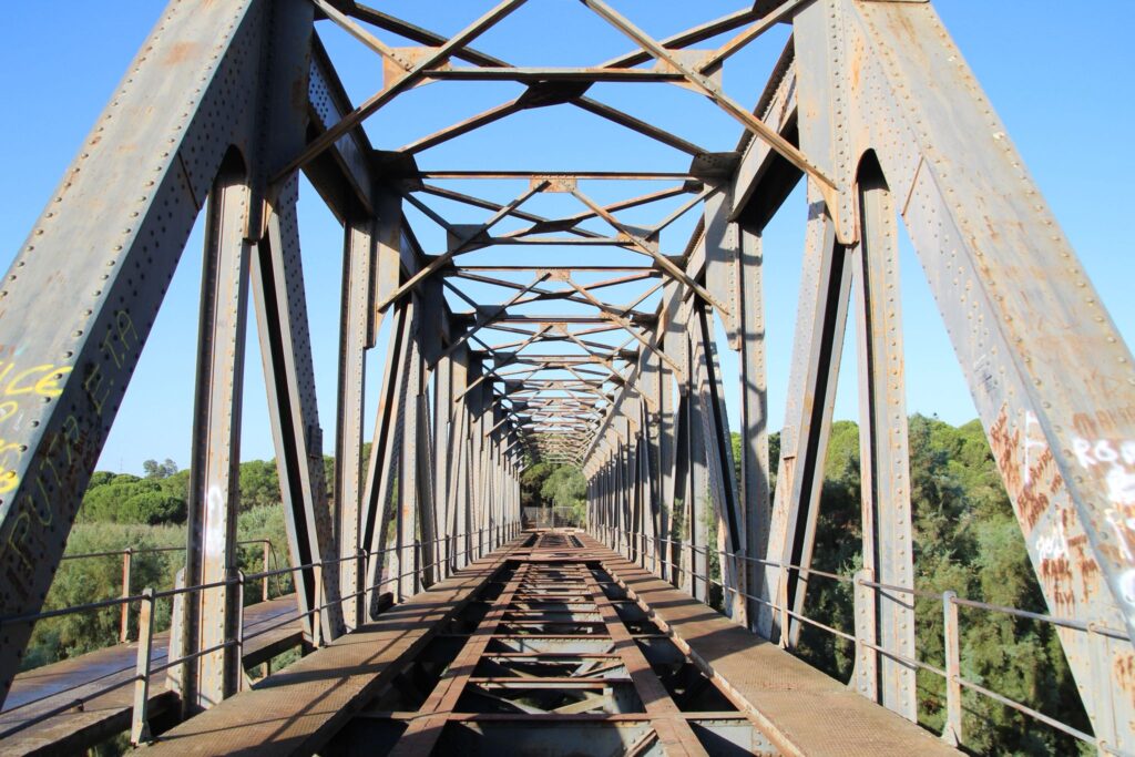
This mountain bike or gravel route starts in Islantilla and follows several sections of the Piedras River, reaching its reservoir. Among other points of interest near this route is the La Tavirona Bridge, an iron bridge that once carried the Huelva-Ayamonte railway line. Built in 1931 using the remains of an old train carriage, it is an impressive 80-meter-long engineering feat. The route presents a moderate challenge due to its ascents and descents.

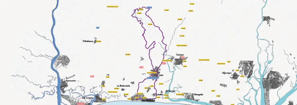
Ruta 4. Mapa de la ruta en bicicleta desde Islantilla hasta el río Piedras.
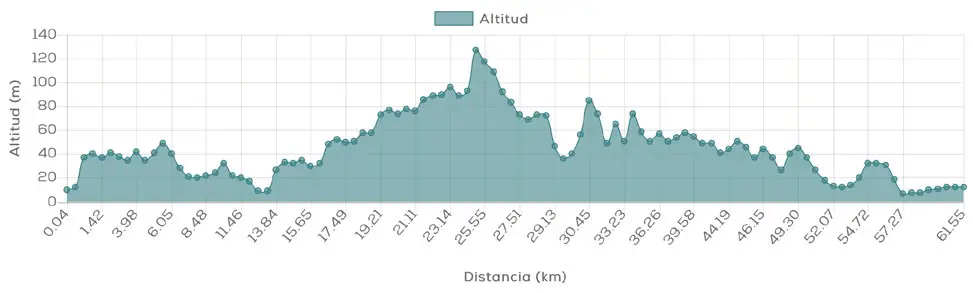
Ruta 4. Perfil de altitud de la ruta cicloturista desde Islantilla al Río Piedras.

Islantilla - Río Piedras

MTB/GRAVEL ROUTE

Ruta 4. Mapa de la ruta en bicicleta desde Islantilla hasta el río Piedras.
Ruta 4. Perfil de altitud de la ruta cicloturista desde Islantilla al Río Piedras.

The bike route Islantilla – Río Piedras It's one of the most comprehensive MTB and gravel routes for exploring the interior of the Western Coast of Huelva. With 60.92 km route, 664 m elevation gain and medium difficulty, It combines tracks and paths with continuous ups and downs that add variety and a point of challenge to the route.

A perfect outing for those who want to combine MTB, gravel, nature and heritage.

Route description

The route begins in Islantilla and gradually moves away from the coast to delve into the landscapes associated with Río Piedras. Along its more than 60 kilometers, the route allows you to discover a different side of the Islantilla environment, dominated by rural paths, pine forests and areas close to the riverbed.

The main destination is the Piedras River Reservoir, This is one of the most interesting scenic spots on the route. The presence of water contrasts with the surrounding vegetation, making this section one of the most attractive places to take a break during the journey.

It's not a completely flat route. The successive ascents and descents and its 664 meters of elevation gain provide a physical component that should be taken into account, especially as kilometers accumulate.

Distance: 60.92km

Altitude: 664m

Difficulty: medium

Route description

The route begins in Islantilla and gradually moves away from the coast to delve into the landscapes associated with Río Piedras. Along its more than 60 kilometers, the route allows you to discover a different side of the Islantilla environment, dominated by rural paths, pine forests and areas close to the riverbed.

The main destination is the Piedras River Reservoir, This is one of the most interesting scenic spots on the route. The presence of water contrasts with the surrounding vegetation, making this section one of the most attractive places to take a break during the journey.

It's not a completely flat route. The successive ascents and descents and its 664 meters of elevation gain provide a physical component that should be taken into account, especially as kilometers accumulate.

Distance:
60.92km

Altitude:
664m

Difficulty:
average

DISCOVER THE TRIPLE DESTINATION ON TWO WHEELS

What makes this route special?

The combination of river landscape, pine forests, elevation change and railway heritage This route differs from other MTB and gravel routes from Islantilla. Its constant changes in terrain and gradient make it enjoyable for cyclists with some experience.

Código QR que enlaza a la ruta cicloturista Islantilla – río Piedras en la web de Cycling Friendly.

Technical specifications of the cycling route

This road route has a total distance of 60.92 km and a cumulative elevation difference of 664 meters, which makes it a viable option medium difficulty.

Download GPX route and navigation

You can download the route track in GPX format and follow the route with your GPS device or cycling app. Additionally, you can access complete information via the QR code. Cycling Friendly.

DISCOVER THE TRIPLE DESTINATION ON TWO WHEELS

What makes this route special?

The combination of river landscape, pine forests, elevation change and railway heritage This route differs from other MTB and gravel routes from Islantilla. Its constant changes in terrain and gradient make it enjoyable for cyclists with some experience.

Código QR que enlaza a la ruta cicloturista Islantilla – río Piedras en la web de Cycling Friendly.

Technical specifications of the cycling route

This road route has a total distance of 60.92 km and a cumulative elevation difference of 664 meters, which makes it a viable option medium difficulty.

Download GPX route and navigation

You can download the route track in GPX format and follow the route with your GPS device or cycling app. Additionally, you can access complete information via the QR code. Cycling Friendly.

Discover more bike routes from Islantilla

If you are interested in cycle tourism in Huelva, from Islantilla you can access numerous routes adapted to all levels:

👉 Islantilla – Coastal Path – Lepe

👉 Islantilla – Islantilla – El Rompido

👉 Islantilla – Greenway – Ayamonte

Discover more bike routes from Islantilla

If you are interested in cycle tourism in Huelva, from Islantilla you can access numerous routes adapted to all levels:

👉 Islantilla – Coastal Path – Lepe

👉 Islantilla – Islantilla – El Rompido

👉 Islantilla – Greenway – Ayamonte