loader-image
22°C

ISLANTILLA - EL ROMPIDO

MTB/GRAVEL ROUTE

Ruta en bicicleta Islantilla - El Rompido
Icono azul de una señal de dirección que representa la distancia de la ruta.

Distance

77.61 km

Icono azul con un triángulo y una pendiente que representa la altitud o desnivel de la ruta en bicicleta.

Altitude

424m

Icono azul de una bicicleta que representa la dificultad del recorrido en bici.

Difficulty

DIFFICULT

A mountain bike or gravel route starting from Islantilla and taking us along rural roads near El Terrón, Lepe, Cartaya, and El Rompido. We'll enjoy views of the mouth of the Piedras River from both sides of the river, in El Terrón and El Rompido, after riding through dense pine forests.

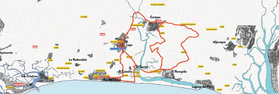
Ruta 6. Mapa de la ruta cicloturista entre Islantilla y El Rompido.
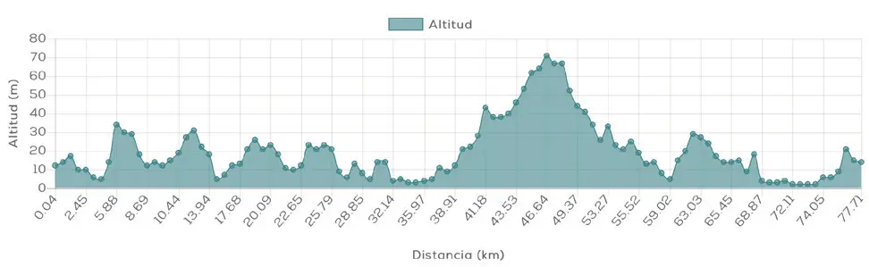
Ruta 6. Perfil de altitud de la ruta cicloturista Islantilla – El Rompido.

Islantilla - El Rompido

MTB/GRAVEL ROUTE

Ruta 6. Mapa de la ruta cicloturista entre Islantilla y El Rompido.
Ruta 6. Perfil de altitud de la ruta cicloturista Islantilla – El Rompido.

The bike route Islantilla – El Rompido It's a mountain bike and gravel route designed for cyclists looking for a challenging day through some of the most attractive natural landscapes on the Huelva coast. At 77.61 km, with 424 m of elevation gain and a difficult difficulty rating, it connects Islantilla with Lepe, El Terrón, Cartaya and El Rompido through rural roads and extensive pine forest areas.

Nature, kilometers and a variety of landscapes make this route an excellent choice.

Route description

The route begins in Islantilla and gradually ventures into the rural paths that connect different enclaves of the western coast of Huelva. Along the route, there are areas close to Lepe, El Terrón, Cartaya and El Rompido, combining tracks and paths surrounded by vegetation.

Its 77.61 kilometers make this route considerably more demanding than other MTB and gravel routes in the area. Although the indicated total elevation gain is 424 meters, the distance and characteristics of the route make experience and good physical fitness advisable.

The goal here isn't just to rack up kilometers: a big part of the appeal lies in cycling between dense pine forests and landscapes linked to the Piedras River, one of the great natural protagonists of the route.

Distance: 77.61km

Altitude: 424m

Difficulty: difficult

Route description

The route begins in Islantilla and gradually ventures into the rural paths that connect different enclaves of the western coast of Huelva. Along the route, there are areas close to Lepe, El Terrón, Cartaya and El Rompido, combining tracks and paths surrounded by vegetation.

Its 77.61 kilometers make this route considerably more demanding than other MTB and gravel routes in the area. Although the indicated total elevation gain is 424 meters, the distance and characteristics of the route make experience and good physical fitness advisable.

The goal here isn't just to rack up kilometers: a big part of the appeal lies in cycling between dense pine forests and landscapes linked to the Piedras River, one of the great natural protagonists of the route.

Distance:
77.61km

Altitude:
424m

Difficulty:
difficult

DISCOVER THE TRIPLE DESTINATION ON TWO WHEELS

What makes this route special?

The combination of distance, rural roads, pine forests and river landscapes makes this route a very comprehensive proposal For experienced cyclists. It also allows you to connect several of the most interesting spots around Islantilla in a single ride.

Qr006

Technical specifications of the cycling route

This road route has a total distance of 77,61 km and a cumulative elevation difference of 424 meters, which makes it a viable option difficulty: difficult.

Download GPX route and navigation

You can download the route track in GPX format and follow the route with your GPS device or cycling app. Additionally, you can access complete information via the QR code. Cycling Friendly.

DISCOVER THE TRIPLE DESTINATION ON TWO WHEELS

What makes this route special?

The combination of distance, rural roads, pine forests and river landscapes makes this route a very comprehensive proposal For experienced cyclists. It also allows you to connect several of the most interesting spots around Islantilla in a single ride.

Qr006

Technical specifications of the cycling route

This road route has a total distance of 77,61 km and a cumulative elevation difference of 424 meters, which makes it a viable option difficulty: difficult.

Download GPX route and navigation

You can download the route track in GPX format and follow the route with your GPS device or cycling app. Additionally, you can access complete information via the QR code. Cycling Friendly.

Discover more bike routes from Islantilla

If you are interested in cycle tourism in Huelva, from Islantilla you can access numerous routes adapted to all levels:

👉 Islantilla – El Rompido

👉 Islantilla – Greenway – Ayamonte

👉 Islantilla – San Silvestre

Discover more bike routes from Islantilla

If you are interested in cycle tourism in Huelva, from Islantilla you can access numerous routes adapted to all levels:

👉 Islantilla – El Rompido

👉 Islantilla – Greenway – Ayamonte

👉 Islantilla – San Silvestre