loader-image
24°C

ISLANTILLA - ISLA CRISTINA

MTB/GRAVEL ROUTE

Ruta en bicicleta Islantilla - Isla Cristina
Icono azul de una señal de dirección que representa la distancia de la ruta.

Distance

43.04 km

Icono azul con un triángulo y una pendiente que representa la altitud o desnivel de la ruta en bicicleta.

Altitude

195m

Icono azul de una bicicleta que representa la dificultad del recorrido en bici.

Difficulty

HALF

A mountain bike or gravel route that takes you from Islantilla to Isla Cristina via the Chameleon Route, and on to Ayamonte along the Coastal Greenway, passing through Pozo del Camino and returning via La Redondela. In Isla Cristina, the route follows the pine forest along the dune system to the Carreras Estuary, as well as the Isla Cristina Salt Flats, traversing part of the Isla Cristina Marshes Natural Area before arriving at the 'Molino del Pintado' Tidal Ecomuseum in Ayamonte.

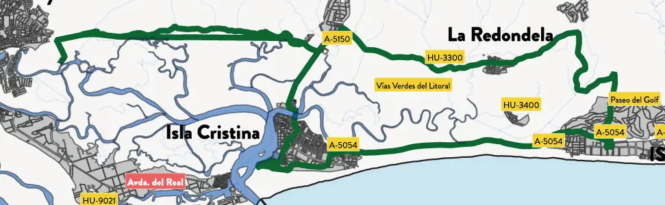
Ruta 1. Mapa de la ruta en bicicleta desde Islantilla hasta Isla Cristina.
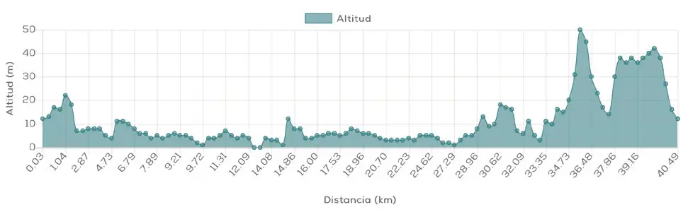
Ruta 1. Perfil de altitud de la ruta cicloturista desde Islantilla hasta Isla Cristina.

Islantilla - Isla Cristina

MTB/GRAVEL ROUTE

Ruta 1. Mapa de la ruta en bicicleta desde Islantilla hasta Isla Cristina.
Ruta 1. Perfil de altitud de la ruta cicloturista desde Islantilla hasta Isla Cristina.

The bike route Islantilla – Isla Cristina It's a tour of MTB and gravel which combines some of the most characteristic natural landscapes of the Western Coast of Huelva. Throughout its 43.04 kilometers, You will cycle through pine forests, dunes, marshes, salt flats and old railway lines, passing through Isla Cristina, Pozo del Camino and Ayamonte before returning to Islantilla via La Redondela.

It combines sport, nature and places of interest without facing great elevation changes.

Route description

The tour begins in Islantilla following the Chameleon Route towards Isla Cristina. The first part allows you to enjoy the coastal landscape and the pine forests near the dune system, an environment that is especially attractive for mountain biking or gravel biking.

Upon reaching Isla Cristina, the route enters one of the most unique landscapes on the Huelva coast. The itinerary crosses the pine forest near the dunes until reaching the Carreras Estuary, where the landscape is marked by water and the maritime tradition of the town.

From here, the tour continues through the surroundings of the Isla Cristina Salt Flats and part of the Isla Cristina Marshes Natural Area, a mosaic of channels, estuaries and salt flats that gives this route a distinct natural character.

Distance: 43.04km

Altitude: 195m

Difficulty: medium

Route description

The tour begins in Islantilla following the Chameleon Route towards Isla Cristina. The first part allows you to enjoy the coastal landscape and the pine forests near the dune system, an environment that is especially attractive for mountain biking or gravel biking.

Upon reaching Isla Cristina, the route enters one of the most unique landscapes on the Huelva coast. The itinerary crosses the pine forest near the dunes until reaching the Carreras Estuary, where the landscape is marked by water and the maritime tradition of the town.

From here, the tour continues through the surroundings of the Isla Cristina Salt Flats and part of the Isla Cristina Marshes Natural Area, a mosaic of channels, estuaries and salt flats that gives this route a distinct natural character.

Distance:
43.04km

Altitude:
195m

Difficulty:
average

DISCOVER THE TRIPLE DESTINATION ON TWO WHEELS

What makes this route special?

This route is especially recommended for those who don't want to limit their cycling outing to just the sporting aspect. Here, the scenery is part of the experience, and it's worth stopping at certain points to admire the surroundings.

Código QR que enlaza a la ruta cicloturista Islantilla – Isla Cristina en Cycling Friendly.

Technical specifications of the cycling route

This road route has a total distance of 43.04 km and a cumulative elevation difference of 195 meters, which makes it a viable option medium difficulty.

Download GPX route and navigation

You can download the route track in GPX format and follow the route with your GPS device or cycling app. Additionally, you can access complete information via the QR code. Cycling Friendly.

DISCOVER THE TRIPLE DESTINATION ON TWO WHEELS

What makes this route special?

This route is especially recommended for those who don't want to limit their cycling outing to just the sporting aspect. Here, the scenery is part of the experience, and it's worth stopping at certain points to admire the surroundings.

Código QR que enlaza a la ruta cicloturista Islantilla – Isla Cristina en Cycling Friendly.

Technical specifications of the cycling route

This road route has a total distance of 43.04 km and a cumulative elevation difference of 195 meters, which makes it a viable option medium difficulty.

Download GPX route and navigation

You can download the route track in GPX format and follow the route with your GPS device or cycling app. Additionally, you can access complete information via the QR code. Cycling Friendly.

Discover more bike routes from Islantilla

If you are interested in cycle tourism in Huelva, from Islantilla you can access numerous routes adapted to all levels:

👉 Islantilla – San Silvestre

👉 Islantilla – Piedras River

👉 Islantilla – Coastal Path – Lepe

Discover more bike routes from Islantilla

If you are interested in cycle tourism in Huelva, from Islantilla you can access numerous routes adapted to all levels:

👉 Islantilla – San Silvestre

👉 Islantilla – Piedras River

👉 Islantilla – Coastal Path – Lepe